
Here at the ASCSA we walk a lot. A. LOT. EVERYWHERE. It’s equally awesome, exhausting, adventurous and insane. We love to hate on our uphill, rocky, slippery (sometimes dark) hikes up and down and around the countryside, ducking under trees, clambering up slopes, scraping ourselves on macquis, twisting ankles, sometimes sweating, sometimes shivering, but all the time exploring, discovering new hidden places and objects, eyes always on the ground, surveying, scanning, searching, laughing, singing, and walking further and further. Always pushing on, always walking.
The landscape of Greece is stunning and diverse and surprising, and while we’ve seen a lot of this country, it’s often sobering to take a look at the paths we forge from another angle: a birds-eye view gives an often drastically different impression of the hikes we’ve been on, and in this post I want to share maps of some of the hikes/walks we’ve been on over the past 5 months. I have a little handheld GPS (a Garmin etrex 20), and by transferring plotted points or paths onto Google Earth, you can see some of the trex (see what I did there?) we’ve done. I’m including some photos taken on the ground as well for comparison. Enjoy!
Bassae Hike
After a presentation and look-around the temple to Apollo Epikourios at Bassae, some of us hiked up to a plateau overlooking much of surrounding Arcadia and south to Lakonia. Here are some pictures of our hike, and then a map showing some of the downfalls of Google Earth imagery (shaky fist at the clouds!) – but keep an eye out for the white tent covering the temple!


OLYNTHOS
I really like this image, which shows the path from the parking lot up to the site at Olynthos – the archaeological site, situated on a plateau known as the ‘North Hill’ is clearly discernible on the right.

UNTRODDEN PHOKIS
Untrodden except by us! Sometimes unwillingly, sometimes confusingly. Here are some maps of the strange places our beloved Whitehead professor afforded us the opportunity to experience.
-
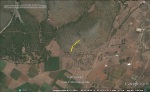
- Hike 1: Fortification Walls aerial view
-
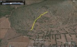
- Hike 1: Fortification Walls angled view
-
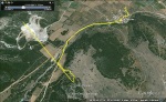
- Hike 2 (plus accidentally leaving the GPS on while in the car)
The third picture is pretty funny because it is our trek, yes, but also the drive to the hike because I forgot to turn off the GPS. I included it because the haphazard lines are a nice reflection of our often-chaotic brains as a result of these surprise after-dark hikes! Here are some photos of just how ‘untrodden’ some of these treks were:


VARI FARMHOUSE
This is a hike we went on last week, and definitely one of the steepest/most daunting. Turns out it wasn’t as bad as it looks, but see for yourself:


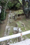
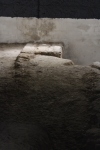
WALL WALKS
Recently we walked (parts of) the ancient wall circuits in both Athens and her harbour, the Piraeus. These are some of my favourite images, mostly because it’s often so difficult to orient yourself to an ancient circuit while within the modern city streets, so literally zooming out and seeing the path from a different perspective is really quite rewarding. Here are the pictures of some of the wall remains in Athens, followed by the map, then pictures of the walls in Piraeus, followed by its map.
-

- Basement of the Islamic Museum
-

- Literally, built on the ancient walls!
-
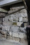
- A plaque identifying the wall…in the place they chopped the wall in half…
-
- Near a parking garage.
-

- In the Divani Acropolis Hotel basement. Poor quality because it’s through glass, but necessary to include because of the fake ivy decoration!
-
- Under a modern apartment building!


And there you have it! Maps are fun! ….and so is hiking. Kind of.

Recent Comments